Festival Directions
See you in Ballard Commons Park on September 28, 2019!
Location: The Festival will be located in Ballard Commons Park at the Intersection of 22nd Ave NW and NW 57th Street, in Downtown Ballard.
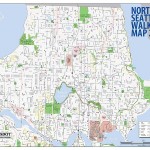
Walking: The best walking approach to Ballard Commons Park is along 22nd Ave NW. From the south, you can come directly north on 22nd. For an east or west approach, try NW 58th Street, or travel along Market St and then north on 22nd.
Biking: There will be plenty of bike racks at the festival. Look for them on the perimeters of the Festival. Please do not lock your bikes to the light poles in the park.
Busing: Bus Routes 40, 44, 61 and the Rapid Ride D Line on 15th all travel within walking distance of the festival. Please consult transit.metrokc.gov for schedules and more information.
Boating: The 24th Street Pier is public and maintained by a group of volunteers. Use is at your own peril and you bear full responsibility for any and all incidents. No overnight moorage allowed. Free. After docking, walk or bike five blocks north and one block east to NW 57th and 22nd NW. The designation Port Ballard appears on the Ballard District Council site.
The coordinates are:
- Latitude: 47° 39′.960 N
- Longitude: 122° 23′.314 W
Driving: Parking will be limited on the day of the festival, so please consider other transportation options and carpooling. If you must drive, try to park in the commercial areas of Ballard. If you do need to park in a residential area, please be respectful of our neighbors and do not block their driveways or make too much festive commotion in their yards.
From I-5, take the 45th Street exit and go west. Follow the arterial as it becomes 46th Street (in Fremont) and then Market Street. Turn right off of Market Street onto 22nd Ave NW. The fest will be north 2 blocks.

